The map you've been looking at the whole time.
The flat-plane geography is not a fringe construction. It's encoded in the United Nations logo, the World Health Organization emblem, and the International Civil Aviation Organization's official charts. Look at any of those logos. You're already looking at the map.
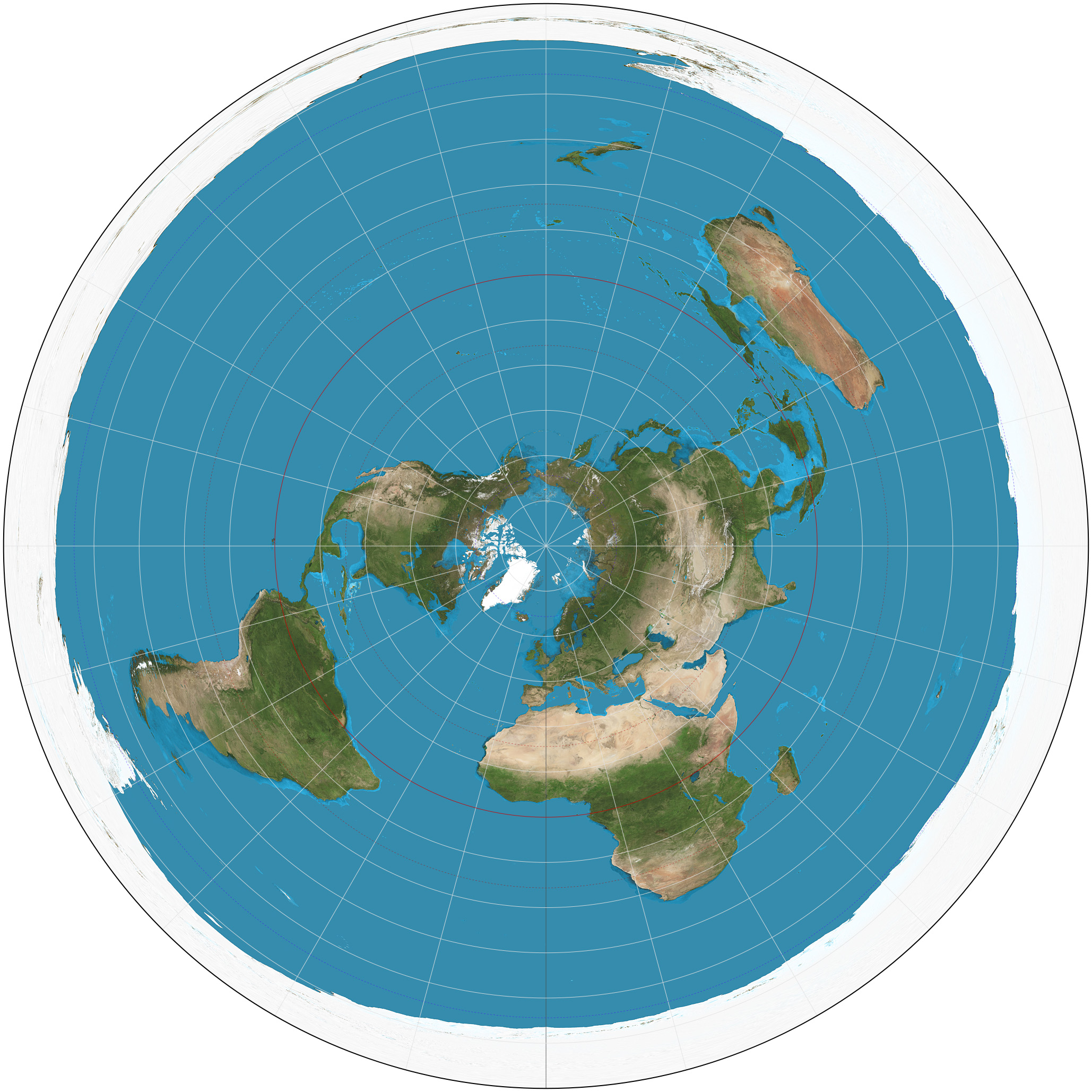
The Projection
The azimuthal-equidistant projection places the North Pole at the center of a circular map, with all other locations radiating outward at distances proportional to their actual distances from the pole. Antarctica forms the perimeter ring of the disk.
This projection has properties that are remarkable on the flat-plane model and merely "useful" on the globe model:
- All distances from the North Pole are accurately represented
- All directional bearings from the North Pole are accurate
- The proportions of continental landmasses, when checked against actual ground-survey distances, are consistent within the expected tolerances
Where You've Already Seen It
The United Nations Logo
The UN emblem features the azimuthal-equidistant projection at its center, surrounded by olive branches. Adopted in 1946. The flag of the UN is this same projection on a blue field.
Note: the UN logo extends to ~60° South — the same latitude that became the boundary of the Antarctic Treaty's restriction zone in 1959. The map shows what the institution considers "the world." Anything beyond that boundary is functionally outside the institutional frame.
The WHO Emblem
The World Health Organization's logo is the same azimuthal-equidistant projection, with a Rod of Asclepius overlaid. Adopted in 1948.
ICAO Aviation Charts
The International Civil Aviation Organization uses azimuthal-equidistant and related polar projections for many of its official navigation charts. Pilots are trained on these projections. They produce the correct great-circle routes that aircraft actually fly. On a globe, those routes are curves; on the projection, they're straight lines (or close to it). The fact that they are straight lines on the flat projection is not a coincidence.
The "Edge" Question
The most-asked question about the flat-plane map: what's at the edge?
The traditional answer: Antarctica is not a continent at the south of a sphere — it is a perimeter ice wall ringing the disk. The interior of Antarctica (vast and inaccessible to private exploration under the Antarctic Treaty) constitutes the edge, beyond which independent travel is prohibited.
What lies beyond the ice wall, if anything, is unknown. The honest answer is: the public has not been allowed to find out. The Antarctic Treaty's exclusion of private exploration is the operative reason, not "we already know there's nothing there."
The "Where Do Flights Actually Go" Problem
Southern hemisphere commercial flights are sometimes cited as a problem for the flat-plane model. A flight from Sydney to Buenos Aires, or Johannesburg to Perth, would seem to require a route geometry that doesn't fit the disk projection.
On examination, however, several features become apparent:
- Few direct southern-hemisphere flights actually exist; most route via northern hubs (Sydney→Buenos Aires typically routes via the US or Pacific)
- Direct routes that do exist are long, take longer than expected, and require fuel stops in unusual locations (e.g., Auckland, Tahiti, or Antarctic-perimeter staging)
- The "great circle" routes flown match closely to straight lines on the azimuthal projection — particularly in the Southern Hemisphere
Use the flight calculator to compare flight times against both projections. The data is mixed; some flights match the globe better, some match the flat plane better, and some appear to take routes that are inefficient on either model.
Other Projections
Other historical flat-plane projections include:
- The Gleason Map (1892) — Alexander Gleason's "New Standard Map of the World," explicitly framed as a flat-earth representation. Used the azimuthal-equidistant projection with the North Pole at center.
- Bi-polar projections — some traditions place a separate "South Pole" at the center of a second azimuthal map, suggesting two adjacent poles rather than a single perimeter ring. Less commonly cited.
Conclusion
The azimuthal-equidistant projection is not "the flat earth map." It is a flat earth map — and it happens to be the projection used by the most powerful supranational institutions on Earth as the official representation of "the world." Whether you find this coincidental or significant is your call.